
Hi, today my blog about is a Cartography (An Ancient Map), the study and practice of making and using maps. Combining science, aesthetics, and technique, cartography builds on the premise that reality can be modeled in ways that communicate spatial information effectively.
History of Cartography:-
The history of cartography traces the development of cartography, or map making technology, in human history. Maps have been one of the most important human inventions for millennia, allowing humans to explain and navigate their way through the world. The earliest surviving maps include cave paintings and etchings on tusk and stone, followed by extensive maps produced by ancient Babylon, Greece and Rome, China, and India. In their most simple form maps are two dimensional constructs, however since the age of Classical Greece maps have also been projected onto a three-dimensional sphere known as a globe. let throw some light on old maps. Before the entire world had been explored people's understanding of geography was very limited. Here are the some amazing old maps.

The Babylonian Map of the world:-
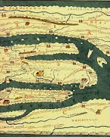 Tabula Peutingeriana Map:-

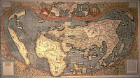 Universalis Cosmographia Map:-

German Cartographers Martin Waldo Mueller and Mathias Ringman created a map in 1507 called. The Universalis Cosmography. The map is amazing because it is the very first time that the word America ever appeared in writing. The universalis cosmography was a printed wall map that showed Africa Europe Asia and the Pacific Ocean, which was not unique to maps at that time however, the map also shows the Americas. The Cartographers placed the name America on South America naming the landmass after Amerigo Vespucci, the famous Italian explorer the map is now preserved at the Library of Congress in Washington DC.

The Vrano Metria Map:-
Not all old maps are maps of the earth. The Vrena Metria was drawn by Johann Bayer in 1603 and it is one of the earliest star atlases. The Vrano Metria’s details the known star constellations at that time and contains 48 maps of the stars. The map is also unique in that the constellations were not drawn on parchment but were carved into copper plates. The title Jana Metria translates as Measuring the Sky which is What this early star atlas attempts to do in fact. The Jana Matria was the very first atlas to attempt to cover the Entire celestial sphere. The constellations are separated into three copper plates one plate, is only of the southern constellations and two other plates are of the northern and southern constellations combined.

Tabula Rogeriana Map:-
The Tabula Rogeriana was created in 1154 by Muhammad Al-Idrisi. Al-Idrisi was a famous Arab Geographer and his map presents an extraordinarily accurate representation of the world but he didn't just draw places and geographical features on his map, he also drew commentaries. The map offers political and cultural commentaries about the seven climate zones seen on the map. These commentaries give modern historians a deeper insight into the communications and relationships between different empires and cultures throughout Europe and Asia. Al-Idrisi was meticulous with his map and spent years interviewing travelers to gather information as such, the Tabula Rogeriana became the most important map of Euro-Asia and Northern Africa for more than three centuries and its commentaries are still studied and used today by historians.

The Mercator Projection Map:-
Is a cylindrical map projection presented by Flemish geographer and cartographer Gerardus Mercator in 1569. It became the standard map projection for navigation because it is unique in representing north as up and south as down everywhere while preserving local directions and shapes. The map is thereby conformal. As a side effect, the Mercator projection inflates the size of objects away from the equator. This inflation is very small near the equator but accelerates with increasing latitude to become infinite at the poles. So, for example, landmasses such as Greenland and Antarctica appear far larger than they actually are relative to landmasses near the equator, such as Central Africa.
Modern methods of transportation, the use of surveillance aircraft, and more recently the availability of satellite imagery have made documentation of many areas possible that were previously inaccessible. Free online services such as Google Earth have made accurate maps of the world more accessible than ever before. For centuries, cartography has helped map our changing world as technology evolves, so do our cartographic capabilities. We can map our city, country, planet, and to an extent - even our universe.
Six Things that Modern Maps Do...
Maps communicate and foster understanding. GIS maps provide windows into useful information. ...
Maps tell stories. ..
Maps can display dynamic information that changes over time. ...
Maps help in finding patterns in mountains of data. ..
Maps help you perform analysis....
Maps can be used to compile data...
“Writing has nothing to do with meaning. It has to do with land-surveying and cartography, including the mapping of countries yet to come.” ― Gilles Deleuze.
“To put a city in a book, to put the world on one sheet of paper -- maps are the most condensed humanized spaces of all...They make the landscape fit indoors, make us masters of sights we can't see and spaces we can't cover.” ― Robert Harbison, Eccentric Spaces.
“Sometimes the exact picture doesn't tell you enough. Sometimes the map is the truth, the picture is a lie.”― Anna Morgan, All That Impossible Space.
“Intentions are like expressways on the map to your future” ― Rachel D. Green-well, How To Wear A Crown: A Practical Guide To Knowing Your Worth.
"Sometimes it is better to work out the map for yourself rather than have it given to you, in terms of learning." -- Anson Jones.
Large & Extra Large Size, Off White Tee Shirts with Old Map Image Printing.

